operational loading or environmental change. Where such movement could affect structural integrity, nearby infrastructure or operational safety, positional change must be measured relative to a stable reference framework.
Deformation monitoring surveys provide objective measurement of structural or ground displacement so that engineers can assess whether movement remains within acceptable limits defined by the project specification.
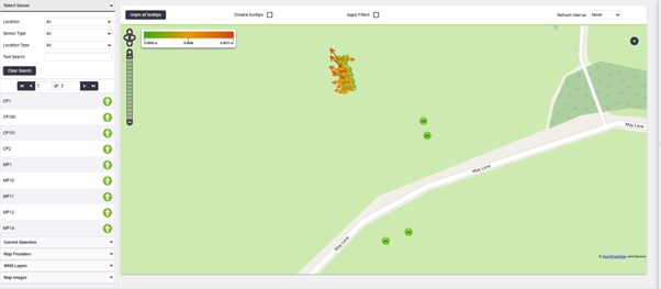
A monitoring scheme begins with the design and establishment of a stable reference control network positioned outside the potential zone of influence. This control framework is verified prior to monitoring observations to ensure that subsequent measurements remain spatially consistent.
Monitoring points are then installed on the structure or ground surface and observed at defined intervals using high-precision survey instrumentation. Measurements are obtained using total stations, GNSS and other survey sensors as appropriate to the required accuracy and site conditions.
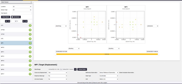
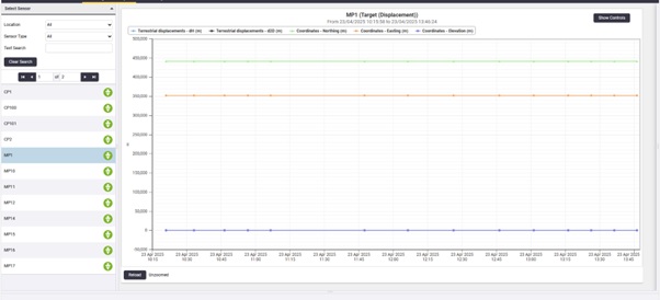
Successive observation epochs are processed within the same coordinate framework to determine positional change relative to the reference network.
Monitoring results are processed and presented in formats suitable for engineering assessment. Typical deliverables include:
Coordinate displacement reports.
Movement vectors showing magnitude and direction of change.
Time-series monitoring data across observation epochs.
Monitoring control network documentation.
Tolerance exceedance alerts.
These datasets allow engineers to assess structural or ground movement using measured evidence rather than visual inspection or assumption.
Profind Surveys starts with a consultation so we understand your requirements and recommend the right approach for your programme and deliverables.


Monitoring scope defined around movement type, risk, frequency and accuracy.
Baseline established under verified control and documented datum.
Repeat observations delivered to a consistent methodology with QA.
Clear reporting and technical clarification to support decisions and assurance.
It’s a standard-led approach to detecting and mapping underground utilities, using suitable methods (often GPR and EML) and clear reporting.
No one can. A good survey can detect up to 95% in the right conditions, but soil, depth, material and site congestion matter.
We scope the site and choose the right mix. Records alone often leave gaps. EML and GPR each have strengths and limits.
Yes. We can convert GPR data into detailed 2D models and support integration with AutoCAD/BIM so the data gets used.
Depends on scope, access, and site constraints. On the scoping call we’ll confirm timescales and what you’ll receive.
Yes — Profind Surveys is based in Tamworth and focuses on the Midlands.
If you require deformation monitoring delivered under defined methodology, verified control and structured QA, contact Profind Surveys Ltd to discuss your assets, risk profile and programme.